The spatial operations
Upload boundaries in any format. Run remote sensing analysis on your AOI.Share results with a single link.
How it works
Three steps from raw boundary to shareable spatial intelligence.
Upload your boundary
Upload a GeoJSON, Shapefile, or KML. The platform reprojects to EPSG:4326, validates geometry, and organises it into your project hierarchy.
Run analysis
Select from 20+ analysis types. Layers are clipped to your AOI with automated metrics extraction — vegetation indices, mineral ratios, terrain derivatives, and more.
Share and collaborate
Generate a share link for any project. Recipients can view the map, download boundaries, and collaborate — no account required.
Three capabilities, one platform
Spatial data management, remote sensing analysis, and field operations planning — unified.
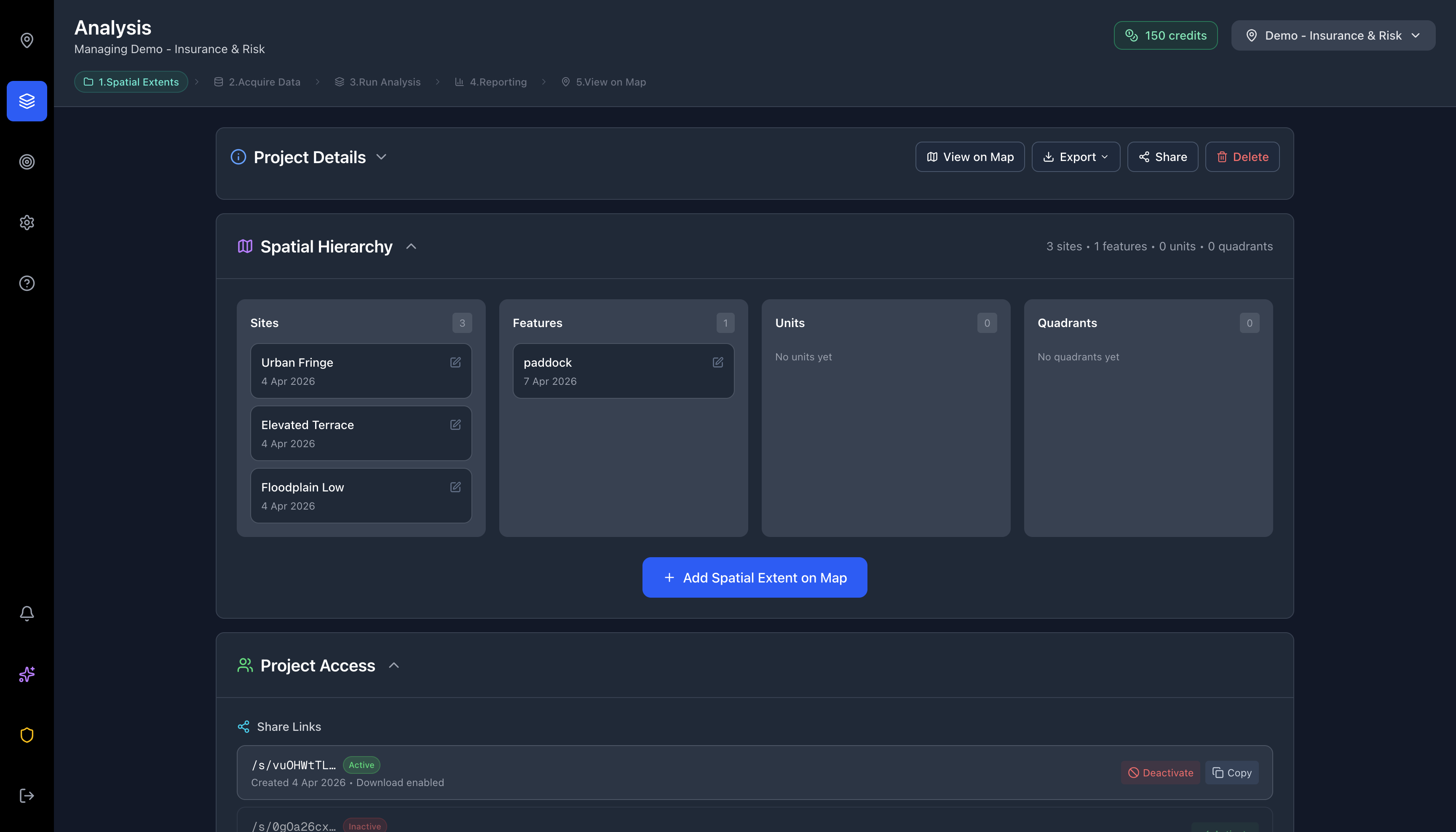
Upload, organise, and share spatial boundaries
Manage project boundaries in a structured hierarchy. Share any project with a single link — recipients can view, download, and collaborate without needing an account.
- Supports GeoJSON, Shapefile (.zip), KML, and KMZ
- 5-level hierarchy: Project → Site → Feature → Unit → Quadrant
- Share links with optional download permissions
- Exportable GeoJSON for use in any GIS platform
Automated spectral indices, composites, and terrain analysis
Run analysis clipped to your area of interest using Sentinel-2 multispectral imagery, AlphaEarth 64-band embeddings, and digital elevation models. Results include automated metrics extraction.
- Sentinel-2 Level-2A multispectral bands
- AlphaEarth 64-band satellite embeddings
- SRTM-derived slope, aspect, and hillshade
- Automated per-feature metrics and distributions
From analysis to action.
Most platforms stop at data delivery. EarthVue connects your spatial analysis directly to field operations, team coordination, and project timelines.
Spatial task management
Create tasks anchored to any level of your spatial hierarchy. A sampling task on a quadrant, an inspection on a site, a review on an entire project — tasks inherit spatial context automatically.
Gantt timeline scheduling
Visualise task dependencies and schedules on a Gantt timeline. Drag to reschedule, filter by spatial entity, and see your entire field programme at a glance across all projects.
Cross-organisation collaboration
Invite consultants, contractors, and regulators into shared project workspaces. Control access with granular roles — from full admin to read-only viewer — across organisations.
The spatial planning loop
Upload boundaries. Run analysis. Identify areas that need attention. Create tasks on those areas. Assign teams. Track completion. Re-analyse to verify. One platform, closed loop.
Start planningUpload spatial boundaries
GeoJSON, Shapefile, KML
Run analysis across time periods
NDVI, erosion risk, disturbance
Create tasks on flagged areas
Anchored to sites, features, units
Schedule on the Gantt timeline
Dependencies, assignments, deadlines
Track and re-analyse
Closed-loop verification
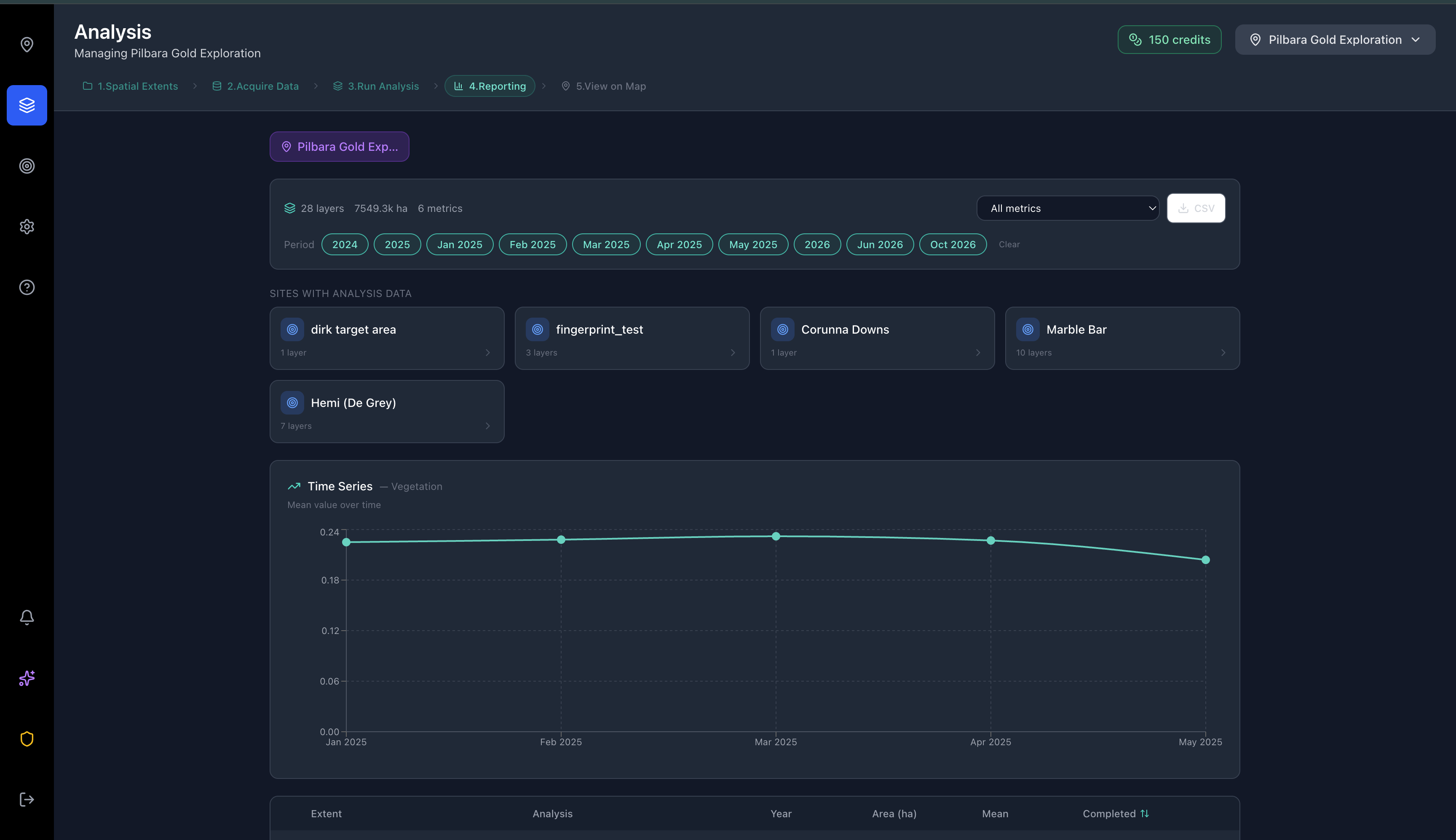
Analysis capabilities
Automated remote sensing indices, mineral composites, terrain derivatives, and 64-band spectral analysis — clipped to your area of interest.

Vegetation Health (NDVI)

Vegetation Cover (FVC)
Water Bodies (NDWI)

Burn Severity (NBR)


64-band satellite embeddings.
Advanced spectral analysis.
AlphaEarth processes 64-band satellite embeddings to enable spectral fingerprinting, similarity mapping, change detection, and anomaly identification across your area of interest.
Fingerprinting
Extract the spectral signature of a known deposit or land cover type, then apply it to any AOI to find spectrally similar targets.
Similarity Search
Select a reference point and map how similar or dissimilar every pixel in your AOI is across all 64 spectral bands.
Change Detection
Compare full 64-band embeddings across two time periods to detect changes not visible in standard RGB or single-index analysis.
Anomaly Detection
Automatically flag spectrally unusual areas without needing a reference — useful for greenfields exploration and environmental screening.
Run the same analysis across years. See what changed.
Select any metric, pick your year range, and compare results side by side. EarthVue automatically generates quantified metrics for each period, then produces an AI-generated report summarising trends, anomalies, and recommendations.
Multi-year comparison
Run any analysis type across consecutive years. See exactly how conditions changed period to period.
Trend quantification
Automated metrics extraction for each time step — mean, distribution, area-weighted statistics, and delta values.
AI report generation
An AI assistant analyses your time-series results and produces a written summary with key findings, statistical trends, and actionable recommendations.
Auditable outputs
Export analysis layers, metrics, and AI-generated reports as evidence for stakeholders, regulators, or internal reviews.
Example: 5-year site analysis
“Consistent upward trend across all periods. Year-on-year improvement averaging +0.15 units. Target threshold of 0.75 exceeded in 2024. Recommend continued monitoring at annual intervals.”
20+
Analysis Types
< 30s
Typical Result Time
5-Level
Spatial Hierarchy
3
Data Sources
Pricing
Start with a free plan. Scale with your team and analysis requirements.
Free
2 one-time credits
2 projects · 2 members
- Sentinel-2 analysis
- Share links
- Community support
Explorer
15 credits/month
3 projects · 3 members
- Sentinel-2 + elevation
- Export & share
- Data requisitions
- Email support
Professional
50 credits/month
Unlimited projects · 10 members
- Full analysis suite
- AlphaEarth Intelligence
- AI Insights
- Priority support
Enterprise
∞ credits/month
Unlimited · Unlimited
- Everything in Professional
- SSO / SAML
- SLA guarantee
- Dedicated CSM
Additional credit packs available from A$10/credit. Credits never expire.
Frequently asked questions
GeoJSON, Shapefile (.zip), KML, and KMZ. Files are automatically reprojected to EPSG:4326 and validated on upload. Maximum file size is 30 MB.
One credit runs a single analysis type — such as an NDVI layer, a mineral ratio composite, or an erosion risk map — clipped to your AOI with automated metrics extraction. Results are typically delivered in under 30 seconds.
No. EarthVue handles reprojection, clipping, and metrics extraction. Upload a boundary, select an analysis type, and receive a finished layer with quantitative metrics.
Generate a unique share link for any project. Recipients can view the map and download GeoJSON — no account required.
AlphaEarth is a 64-band satellite embedding product. It enables spectral fingerprinting, similarity search, change detection, and anomaly detection — analysis types not available through standard multispectral imagery. Available on Professional plans.
Free accounts receive 2 one-time analysis credits. Paid plans include a monthly credit allocation. Additional credits can be purchased in packs at top-up rates (from A$10/credit in larger packs). Credits never expire.
All data is stored with row-level security on SOC 2-compliant infrastructure. Share tokens are scoped to individual projects, and service keys are server-side only.
Yes. Every project and analysis layer can be downloaded as GeoJSON for use in any downstream workflow or GIS platform.
Your spatial operations,
unified
Upload, analyse, share, and plan — in one platform built for spatial teams.